Converting Regions to Shapely Objects
The Shapely Python package is a generic package for the manipulation and analysis of geometric objects in the Cartesian plane. For regions in the cartesian plane, it is more feature-complete, powerful, and optimized than this package.
The use of Shapely or other Python regions packages that come from the
geospatial domain in Astronomy is rare. However, if you have a complex
pixel region analysis task, you can consider using Shapely. Either use
it directly, by defining Shapely regions via Python code or one of the
serialization formats they support, or by writing some Python code to
convert Region objects to Shapely objects.
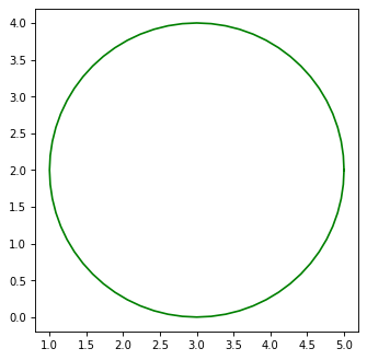
Here we give an example of converting a circle to a Shapely object and then polygonize it. One nice feature of Shapely is that it can polygonize all shapes and perform fast polygon-based computations like intersection and union.
import matplotlib.pyplot as plt
from regions import PixCoord, CirclePixelRegion
from shapely.geometry import Point

# Make an example region
region = CirclePixelRegion(center=PixCoord(3, 2), radius=2)

# Convert to Shapely
point = Point(region.center.x, region.center.y)
circle = point.buffer(region.radius)

# Actually, this is a polygon approximation of the circle
print(circle)

# Plot the result
x, y = circle.exterior.xy
ax = plt.subplot(1, 1, 1)
ax.set_aspect('equal')
ax.plot(x, y, 'g-')
(Source code, png, hires.png, pdf, svg)